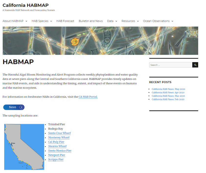
Easy access to timely, reliable information enables solutions to mitigating the effects of climate change, sea-level rise, contaminant spills, and harmful algal blooms. CeNCOOS supports readiness and resilience to coastal hazards in the region by providing existing federal, state, and municipal programs with state-of-the-art data, tools and training to advance planning and response to storms, accidents, and the presence of litter, microplastics, pollutants and HAB toxins.
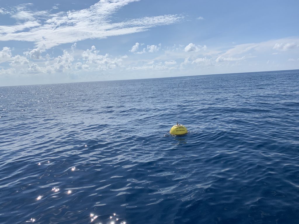
Navigation & Boaters
![]()
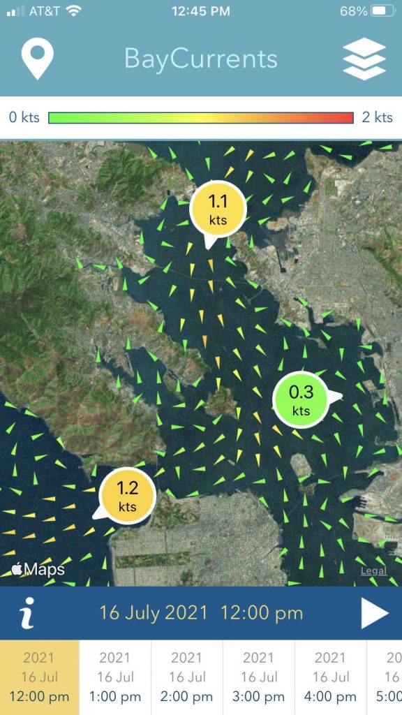 BayCurrents is a mobile app for displaying maps of high resolution surface currents within the San Francisco Bay. The app Read more
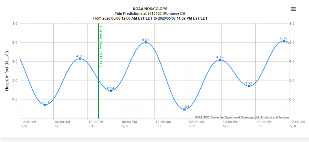 NOAA’s Center for Operational Oceanographic Products and Services (CO-OPS) is the authoritative source for accurate, reliable, and timely tides, water Read more
 San Francisco specific tides and conditions are presented in the following links. NOAA tidal predictions for San Francisco Bay are Read more
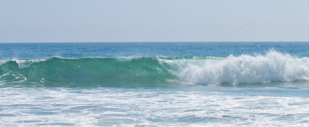
 The coastal Data Information Program (CDIP) specializes in wave measurement, swell modeling and forecasting, and the analysis of environmental data. Read more
BayCurrents is a mobile app for displaying maps of high resolution surface currents within the San Francisco Bay. The app Read more
NOAA’s Center for Operational Oceanographic Products and Services (CO-OPS) is the authoritative source for accurate, reliable, and timely tides, water Read more
San Francisco specific tides and conditions are presented in the following links. NOAA tidal predictions for San Francisco Bay are Read more
The coastal Data Information Program (CDIP) specializes in wave measurement, swell modeling and forecasting, and the analysis of environmental data. Read more
Fisheries & Aquaculture
![]()
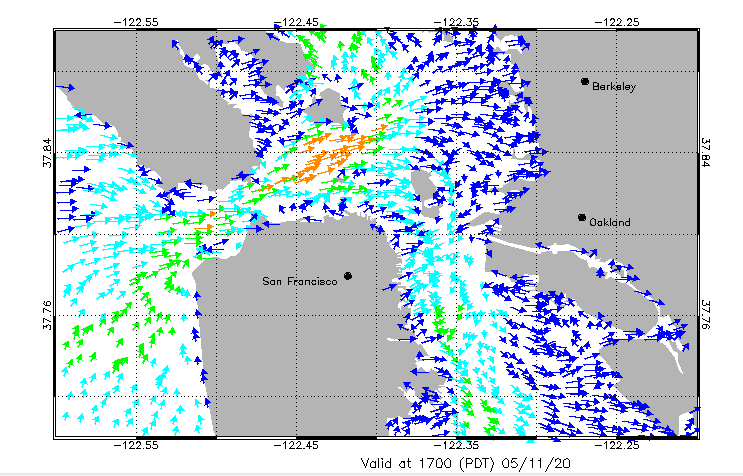
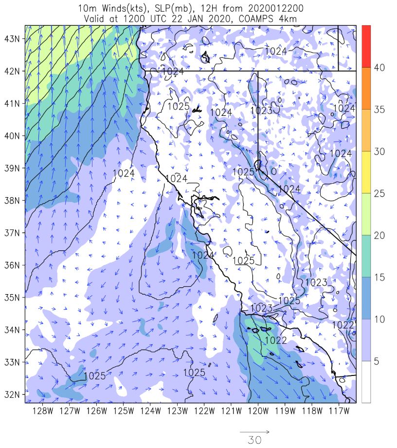
 Data are updated every hour. Click and drag to zoom and double-click to reset the zoom. The arrow represents the Read more
Data are updated every hour. Click and drag to zoom and double-click to reset the zoom. The arrow represents the Read more
Data are updated every hour. Click and drag to zoom and double-click to reset the zoom. The arrow represents the Read more
Data are updated every hour. Click and drag to zoom and double-click to reset the zoom. The arrow represents the Read more
Data are updated every hour. Click and drag to zoom and double-click to reset the zoom. The arrow represents the Read more
Data are updated every hour. Click and drag to zoom and double-click to reset the zoom. The arrow represents the Read more
Data are updated every hour. Click and drag to zoom and double-click to reset the zoom. The arrow represents the Read more
Data are updated every hour. Click and drag to zoom and double-click to reset the zoom. The arrow represents the Read more
Data are updated every hour. Click and drag to zoom and double-click to reset the zoom. The arrow represents the Read more
Data are updated every hour. Click and drag to zoom and double-click to reset the zoom. The arrow represents the Read more
Data are updated every hour. Click and drag to zoom and double-click to reset the zoom. The arrow represents the Read more
Data are updated every hour. Click and drag to zoom and double-click to reset the zoom. The arrow represents the Read more
Data are updated every hour. Click and drag to zoom and double-click to reset the zoom. The arrow represents the Read more
Data are updated every hour. Click and drag to zoom and double-click to reset the zoom. The arrow represents the Read more
MPAs & Sanctuaries
Climate & Ecosystem Indicators
![]()
 Multivariate Ocean Climate Indicator (MOCI) Read more
Multivariate Ocean Climate Indicator (MOCI) Read more
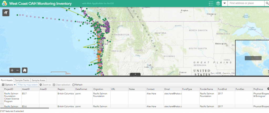
Ocean Acidification & Hypoxia
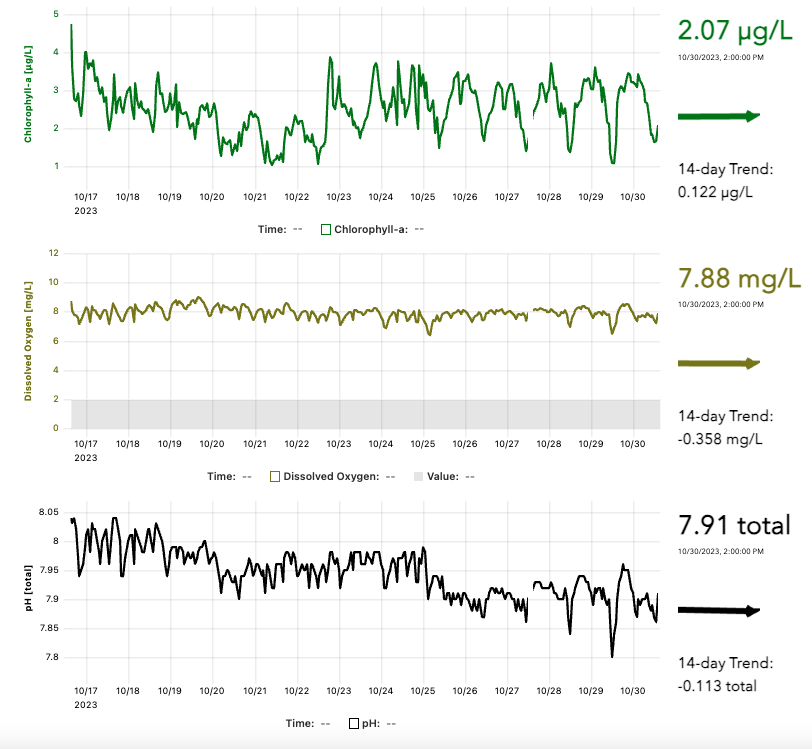
![]() Figure Credit: Kathleen Pitz Access the full paper: https://doi.org/10.5670/oceanog.2017.429 Read more
Data are updated every hour. Click and drag to zoom and double-click to reset the zoom. The arrow represents the Read more
Data are updated every hour. Click and drag to zoom and double-click to reset the zoom. The arrow represents the Read more
Data are updated every hour. Click and drag to zoom and double-click to reset the zoom. The arrow represents the Read more
Data are updated every hour. Click and drag to zoom and double-click to reset the zoom. The arrow represents the Read more
Data are updated every hour. Click and drag to zoom and double-click to reset the zoom. The arrow represents the Read more
Figure Credit: Kathleen Pitz Access the full paper: https://doi.org/10.5670/oceanog.2017.429 Read more
Data are updated every hour. Click and drag to zoom and double-click to reset the zoom. The arrow represents the Read more
Data are updated every hour. Click and drag to zoom and double-click to reset the zoom. The arrow represents the Read more
Data are updated every hour. Click and drag to zoom and double-click to reset the zoom. The arrow represents the Read more
Data are updated every hour. Click and drag to zoom and double-click to reset the zoom. The arrow represents the Read more
Data are updated every hour. Click and drag to zoom and double-click to reset the zoom. The arrow represents the Read more