“Biologging” through temporary attachment of miniaturized tags or ‘data loggers’ on marine animals offers new capabilities to observe the ocean and has the potential to revolutionize the science of marine ecology. In addition to collecting location and depth information, useful for studying animal movement and behavior; the vertical profiles of temperature and salinity data collected by these devices can be used to improve knowledge of ocean state and its variability.1
This vertical oceanographic profile data from animal-borne sensor tags complements profiling float and other autonomous vehicle data to provide unique and cost-effective data from poorly sampled ocean regions, and is rapidly becoming a valuable component of regional and global ocean observing systems, especially at high latitudes. The tagged animals routinely provide vertical oceanographic profiles throughout the upper 1500 m of the water column and in some cases deeper (2000 m). Animals travel to regions that are relatively inaccessible to other ocean observing technologies, such as the polar oceans beneath seasonal or permanent sea ice or remote atolls such as those in the Northwest Hawaiian Islands. Additionally, animals move into locations and sample where Argo floats are often pushed away (upwelling zones) and across political boundaries. These data can be used to improve global and regional ocean forecasting systems by reducing initial condition errors, which can increase our understanding of ecosystem processes and improve predictions of future ecosystem responses to anthropogenic disturbances, storms, floods, drought, climatic variation, extreme weather events and HABs.
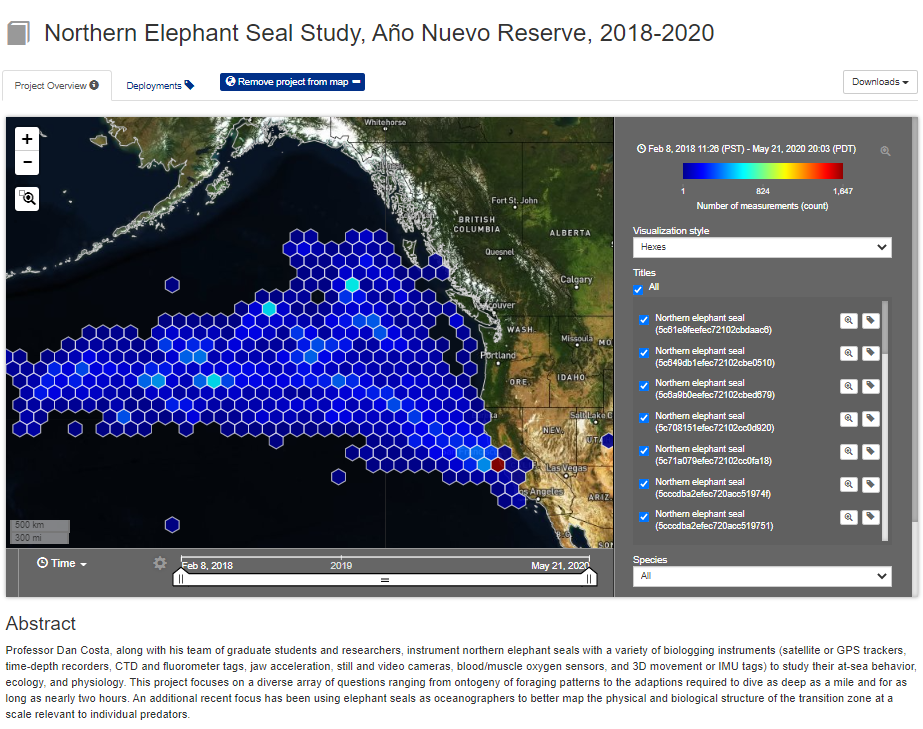
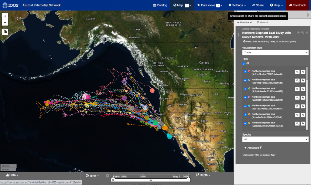
U.S. Animal Telemetry Network (ATN)
Presently, the U.S. Animal Telemetry Network (ATN) Data Assembly Center (DAC) serves as the national aggregator of all marine animal telemetry data, including oceanographic profiles. ATN also facilitates the public dissemination of telemetry data, and provides access to a unique sets of data products and data management tools. In particular, satellite‐linked animal-borne sensor tags provide real‐time (R/T) data to the DAC, which is displayed in the public-facing, web-based data portal (https://portal.atn.ioos.us). For more information on the U.S. ATN, please visit our website: https://ioos.noaa.gov/project/atn/.
A goal of the ATN DAC is to make the vertical ocean profile data collected by these animal-borne sensor tags easily and rapidly available to the global ocean and marine meteorological community. This will be accomplished by developing and implementing in the DAC a set of R/T processes that build on, streamline and operationalize a similar approach successfully implemented by the Sea Mammal Research Unit (SMRU) within the Scottish Ocean Institute at the University of St. Andrews. Specific ATN DAC improvements to the SMRU process will include applying R/T operational Quality Control (QC) methods and creating table-driven Binary Universal Format for Representation (BUFR) coded messages, rather than the older alphanumeric character-based coded messages, e.g., TESAC (Temperature, Salinity, Current), to be inserted onto the Global Telecommunications System (GTS).
The ATN DAC automated and operational R/T processes/pathway will contain the following functional components:
- Acquiring the animal-borne tag data via automated pathways with tag manufacturers, Institutions and Argos (initially from Wildlife Computers and SMRU)
- Performing R/T QC on the profile measurements and the tag geolocations
- Transforming the profiles in R/T into the table-driven BUFR coded messages required by the World Meteorological Organization’s (WMO) GTS
- Pushing these BUFR messages electronically to NOAA’s National Data Buoy Center (NDBC) where they will be inserted onto the GTS